April 1 2024 marks the 725th anniversary of King Edward I granting royal charters to two settlements in the north of England: Kingston upon Hull and Ravenser Odd.
The first, of course, is better known as Hull, the city on the banks of the Humber estuary that today handles a quarter of UK seaborne trade.

Edward I. Wikimedia
Few will have heard of the second, though. Despite its relative importance in 1299, today, Ravenser Odd has been largely forgotten – because it disappeared, swallowed by the North Sea. It is, as one journalist put it, “Yorkshire’s Atlantis”.
Since 2021, I have taken responsibility for the seafloor searches for Ravenser, using high-resolution seafloor mapping equipment and interpreting the resulting data with local historian Phil Mathison. The story of Ravenser Odd and the search for its remains are the focus of an exhibition at the Hull History Centre.
The northern city that sank
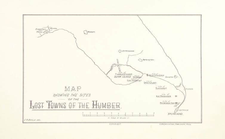
Ravenser Odd began life as a port on the narrow spit of shingle and clay known as Spurn Head that forms the north bank of the mouth of the Humber. The town grew into a prosperous settlement.

The Lost Towns of the Humber. British Library|Wikimedia
The 1299 charter made Ravenser into a recognised borough and exempted its merchants from some taxes. This allowed the town to build its own court, jail and chapel. It was represented by two members of parliament.
The town contributed ships to Edward I and Edward II’s wars with Scotland. Life in the town was lawless. Its envious rivals on the Humber, Grimsby and Hull, accused Ravenser of piracy, as did German merchants and the king of Norway.

Edward II. British Library|Wikimedia
By the mid-14th century, the storms and strong tidal currents of the North Sea began to take their toll on the settlement. A devastating blow was dealt in 1362 by the storm surge of St Marcellus’s flood after which the town began to be abandoned.
The very forces that created the land that Ravenser was situated on – and gave it an advantage over other ports on the Humber – were to end its pre-eminence as a trading hub. As recorded in the Meaux Abbey Chronicle, by the end of the 14th century, corpses in the graveyard were being exposed by the sea. There were reports of looting of the chapel by “sacrilegious persons”.
Coastal erosion
The Holderness coastline, to the north of the Spurn peninsula, is the fastest eroding coastline in Europe. Its crumbling cliffs of soft boulder clay are retreating at an average rate of two metres a year.
Thirty settlements are known to have been lost. The location of Ravenser Odd, though, has long remained contested because the historical evolution of Spurn Head remains uncertain. There have been no reports of structures from Ravenser for over 500 years. Suggested locations are thus linked to the various theories on the evolution of Spurn Head.
One theory, put forward in the 1960s, describes a 250-year cyclical evolution of Spurn in which the peninsula gradually extends further across the mouth of the Humber until it is breached. The resulting island gradually erodes while a new spit is formed further inland. This would place Ravenser around 2km offshore from the present peninsula.
Other theories suggest that the neck of the peninsula retreats constantly in line with the erosion of Holderness. This places Ravenser not far from the current shoreline.
Still, other theories site Ravenser on an area of shingle on the Humber side of Spurn Head that is uncovered at low tide. Some remains of buildings were discovered here in the 19th century, although they may date from later historical periods than the records we have of Ravenser.
Spurn’s remoteness and the inhospitable conditions of the North Sea give the peninsula a feeling of otherworldliness. The sense of isolation was enhanced in 2013 when the road along the 3km-long peninsula was cut off by a storm surge.
Conditions in the estuary make it difficult to search for traces of the lost town. In late 2021, Phil Mathison set up a collaboration with Hull University to survey the seafloor.
The high-resolution survey instrument we used, a multibeam echosounder, is routinely used by earth scientists, harbour authorities and archaeologists to map the seafloor. Our survey focused on an area where a seafloor anomaly had been previously seen by Mathison.
However, we failed to identify anything that could be identified as structural remains. This could be due to the constantly shifting sediment of the seafloor.
We will continue the hunt for Ravenser using instruments called parametric echosounders. These are capable of probing below the layers of seafloor sediment and would be deployed at locations identified as areas of interest from the previous surveys.
Land surveys of the subsurface would be possible using a combination of ground-penetrating radar and magnetic gradiometry during low tide. The latter was recently used to discover the remains of the village of Rungholt off the coast of Germany, also lost to St Marcellus’s storm of 1362.
In a region where life on the coastline remains precarious, the focus of the 725th anniversary of Ravenser’s charter has renewed interest in the town and its historical and symbolic importance. As our climate continues to warm, difficult coastal management decisions will be exacerbated by the increased likelihood of storms. This makes the story of the city Yorkshire lost poignantly relevant.


 BTC Flat at $89,300 Despite $1.02B ETF Exodus — Buy the Dip Toward $107K?
  Nasdaq Proposes Fast-Track Rule to Accelerate Index Inclusion for Major New Listings
  JPMorgan Lifts Gold Price Forecast to $6,300 by End-2026 on Strong Central Bank and Investor Demand


